


2.

ROBERT-MICHEL
User

Length
2.3 km

Max alt
86 m

Uphill gradient
28 m
Km-Effort
2.7 km

Min alt
63 m

Downhill gradient
19 m
Boucle
No
Creation date :
2019-07-07 09:35:13.624
Updated on :
2019-07-07 10:22:17.48
46m
Difficulty : Very easy

FREE GPS app for hiking
 SityTrail
IGN / Geographical institutes
SityTrail Plus
The world is yours!
About
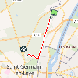
Trail Walking of 2.3 km to be discovered at Ile-de-France, Yvelines, Saint-Germain-en-Laye. This trail is proposed by ROBERT-MICHEL.
Description
terr2
Positioning
Country:
France
Region :
Ile-de-France
Department/Province :
Yvelines
Municipality :
Saint-Germain-en-Laye
Location:
Saint-Germain-en-Laye
Start:(Dec)
Start:(UTM)
434698 ; 5418689 (31U) N.
Comments