


la roche guyon

ghislainem
User
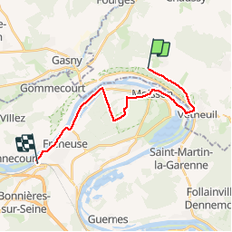

Length
18.4 km

Max alt
151 m

Uphill gradient
137 m
Km-Effort
21 km

Min alt
11 m

Downhill gradient
253 m
Boucle
No
Creation date :
2019-07-07 09:55:28.987
Updated on :
2019-07-07 15:13:37.688
3h37
Difficulty : Very easy

FREE GPS app for hiking
 SityTrail
IGN / Geographical institutes
SityTrail Plus
The world is yours!
About
Trail Walking of 18.4 km to be discovered at Ile-de-France, Val-d'Oise, Haute-Isle. This trail is proposed by ghislainem.
Positioning
Country:
France
Region :
Ile-de-France
Department/Province :
Val-d'Oise
Municipality :
Haute-Isle
Location:
Unknown
Start:(Dec)
Start:(UTM)
402553 ; 5437852 (31U) N.
Comments