Trail Walking Cras - boucle mossoronniere oppidum murcens vallée de la rose - Photo

boucle mossoronniere oppidum murcens vallée de la rose

 Glurps
Glurps

User

© OpenStreetMap contributors
Length
Length
18.4 km
Max alt
Max alt
358 m
Uphill gradient
Uphill gradient
525 m
Km-Effort
Km-Effort  
25 km
Min alt
Min alt
176 m
Downhill gradient
Downhill gradient
525 m
Boucle
Boucle
Yes
Creation date :
2014-12-10 00:00:00.0
Updated on :
2014-12-10 00:00:00.0

(0 Reviews)

Walking
Walking
6h25
Difficulty : Difficult

Scan this QR Code to open this trail in the SityTrail application

FREE GPS app for hiking

Logo SityTrail SityTrail

IGN / Geographical institutes

Download SityTrail from the App Store Download SityTrail from Google Play

Logo SityTrail SityTrail World

The world is yours!

Download SityTrail from the App Store Download SityTrail from Google Play Download SityTrail on Huawei AppGallery

About

Trail Walking of 18.4 km to be discovered at Occitania, Lot, Cras. This trail is proposed by Glurps.

Description

Attention la boucle dans l oppidum est sportive au niveau des falaises pour la remontée depuis la rivière par la grotte des blés

Elevation profile

Photos

Positioning

Country:
France
Region :
Occitania
Department/Province :
Lot
Municipality :
Cras
Location:
Unknown
Start:(UTM)
384217 ; 4935825 (31T) N.

Trails nearby

Trail Walking Les Pechs-du-Vers - Saint Martin - Lauzès2-12656076 - Photo
Walking
houbart

Walking

Very difficult
(1)
Les Pechs-du-Vers, Occitania, Lot, France
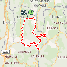
13.6 km | 19 km-effort
4h 19min
Yes
Trail Walking Les Pechs-du-Vers - Saint Martin de vers  - Photo
Walking
GUIDE
antignacs

Walking

Very easy
Les Pechs-du-Vers, Occitania, Lot, France
10.6 km | 13.4 km-effort
2h 30min
Yes
Trail Walking Cœur de Causse - 2022-04-25_07h04m03_46 - St Sauveur la Vallée - 14 Km - Photo
Walking
houbart

Walking

Very difficult
Cœur de Causse, Occitania, Lot, France
14.4 km | 19.4 km-effort
4h 24min
Yes
Trail Walking Cras - Guillot Gironde Cras Murcens  - Photo
Walking
GUIDE
antignacs

Walking

Easy
Cras, Occitania, Lot, France
14 km | 19.3 km-effort
3h 16min
Yes
Trail Walking Francoulès - Francoules  - Photo
Walking
GUIDE
antignacs

Walking

Very easy
Francoulès, Occitania, Lot, France
9 km | 11.9 km-effort
1h 57min
Yes
Trail Walking Cras - guillotine bout de la côté - Photo
Walking
GUIDE
antignacs

Walking

Very easy
Cras, Occitania, Lot, France
7.1 km | 9.5 km-effort
1h 45min
Yes
Trail Mountain bike Les Pechs-du-Vers - 2022-07-04_13h05m38_Boucle des Châtaigneraies du Causse - Photo
Mountain bike
sebcar

Mountain bike

Easy
Les Pechs-du-Vers, Occitania, Lot, France
11.5 km | 15.1 km-effort
1h 2min
Yes
Trail Mountain bike Cras - 2022-07-04_13h02m11_La Boucle du Vers en Géocaching - Photo
Mountain bike
sebcar

Mountain bike

Difficult
Cras, Occitania, Lot, France
30 km | 38 km-effort
2h 36min
Yes
Trail Walking Cras - Randonnée du 29/05/2022 à 15:58 - Photo
Walking
houbart

Walking

Very difficult
Cras, Occitania, Lot, France
15.4 km | 22 km-effort
4h 57min
Yes


Close
My subscriptions