


Bucey en Othe

FPortier
User
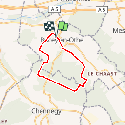

Length
10 km

Max alt
248 m

Uphill gradient
167 m
Km-Effort
12.3 km

Min alt
159 m

Downhill gradient
166 m
Boucle
Yes
Creation date :
2019-07-09 07:00:34.219
Updated on :
2019-07-09 10:03:03.46
2h38
Difficulty : Very easy

FREE GPS app for hiking
 SityTrail
IGN / Geographical institutes
SityTrail Plus
The world is yours!
About
Trail Walking of 10 km to be discovered at Grand Est, Aube, Bucey-en-Othe. This trail is proposed by FPortier.
Description
Balade chemins champ chemins bois
Photos


Positioning
Country:
France
Region :
Grand Est
Department/Province :
Aube
Municipality :
Bucey-en-Othe
Location:
Unknown
Start:(Dec)
Start:(UTM)
563840 ; 5345568 (31U) N.
Comments