


2019-07-09 Visite St Véran

Bernardb44
User
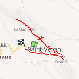

Length
2.6 km

Max alt
2057 m

Uphill gradient
79 m
Km-Effort
3.6 km

Min alt
1969 m

Downhill gradient
87 m
Boucle
Yes
Creation date :
2019-07-09 13:48:37.482
Updated on :
2019-07-09 16:14:58.863
2h25
Difficulty : Very easy

FREE GPS app for hiking
 SityTrail
IGN / Geographical institutes
SityTrail Plus
The world is yours!
About
Trail Walking of 2.6 km to be discovered at Provence-Alpes-Côte d'Azur, Hautes-Alpes, Saint-Véran. This trail is proposed by Bernardb44.
Positioning
Country:
France
Region :
Provence-Alpes-Côte d'Azur
Department/Province :
Hautes-Alpes
Municipality :
Saint-Véran
Location:
Unknown
Start:(Dec)
Start:(UTM)
330992 ; 4951743 (32T) N.
Comments