


balade dans BRIGNAIS

dan69390
User
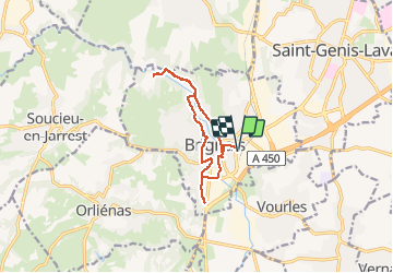

Length
11.2 km

Max alt
240 m

Uphill gradient
97 m
Km-Effort
12.5 km

Min alt
202 m

Downhill gradient
97 m
Boucle
Yes
Creation date :
2014-12-10 00:00:00.0
Updated on :
2014-12-10 00:00:00.0
54m
Difficulty : Very easy

FREE GPS app for hiking
 SityTrail
IGN / Geographical institutes
SityTrail Plus
The world is yours!
About
Trail Cycle of 11.2 km to be discovered at Auvergne-Rhône-Alpes, Rhône, Brignais. This trail is proposed by dan69390.
Positioning
Country:
France
Region :
Auvergne-Rhône-Alpes
Department/Province :
Rhône
Municipality :
Brignais
Location:
Unknown
Start:(Dec)
Start:(UTM)
637200 ; 5059187 (31T) N.
Comments