


Samoens

c.gourme
User

Length
5.7 km

Max alt
1060 m

Uphill gradient
319 m
Km-Effort
9.9 km

Min alt
749 m

Downhill gradient
319 m
Boucle
Yes
Creation date :
2019-07-09 06:36:48.0
Updated on :
2019-07-10 12:01:32.082
1h56
Difficulty : Easy

FREE GPS app for hiking
 SityTrail
IGN / Geographical institutes
SityTrail Plus
The world is yours!
About
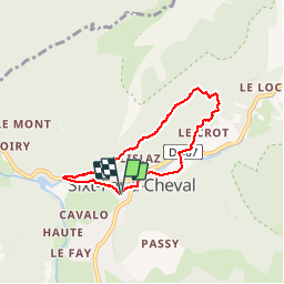
Trail Walking of 5.7 km to be discovered at Auvergne-Rhône-Alpes, Upper Savoy, Sixt-Fer-à-Cheval. This trail is proposed by c.gourme.
Positioning
Country:
France
Region :
Auvergne-Rhône-Alpes
Department/Province :
Upper Savoy
Municipality :
Sixt-Fer-à-Cheval
Location:
Unknown
Start:(Dec)
Start:(UTM)
327789 ; 5102418 (32T) N.
Comments