


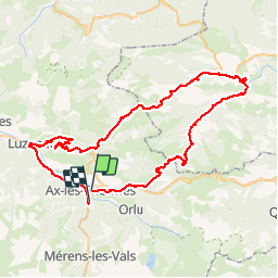
Ax les thermes

ARVIEU
User

Length
84 km

Max alt
1689 m

Uphill gradient
2450 m
Km-Effort
117 km

Min alt
597 m

Downhill gradient
2393 m
Boucle
No
Creation date :
2019-07-10 14:00:18.301
Updated on :
2019-07-10 14:19:18.359
4h00
Difficulty : Very easy

FREE GPS app for hiking
 SityTrail
IGN / Geographical institutes
SityTrail Plus
The world is yours!
About
Trail Cycle of 84 km to be discovered at Occitania, Ariège, Ax-les-Thermes. This trail is proposed by ARVIEU.
Positioning
Country:
France
Region :
Occitania
Department/Province :
Ariège
Municipality :
Ax-les-Thermes
Location:
Unknown
Start:(Dec)
Start:(UTM)
405041 ; 4730517 (31T) N.
Comments