


Le Haut du Tôt

aout60
User
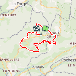

Length
14.8 km

Max alt
857 m

Uphill gradient
491 m
Km-Effort
21 km

Min alt
561 m

Downhill gradient
493 m
Boucle
Yes
Creation date :
2019-07-10 09:54:57.775
Updated on :
2019-07-11 07:21:23.649
5h03
Difficulty : Medium

FREE GPS app for hiking
 SityTrail
IGN / Geographical institutes
SityTrail Plus
The world is yours!
About
Trail Walking of 14.8 km to be discovered at Grand Est, Vosges, Vagney. This trail is proposed by aout60.
Photos


Positioning
Country:
France
Region :
Grand Est
Department/Province :
Vosges
Municipality :
Vagney
Location:
Unknown
Start:(Dec)
Start:(UTM)
332380 ; 5323387 (32U) N.
Comments