


cascade d'ars

Chapatann
User
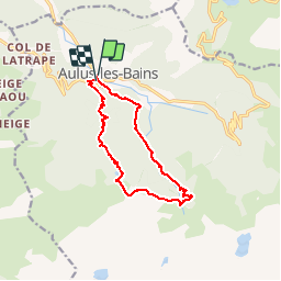

Length
12.1 km

Max alt
1592 m

Uphill gradient
875 m
Km-Effort
24 km

Min alt
742 m

Downhill gradient
858 m
Boucle
Yes
Creation date :
2014-12-10 00:00:00.0
Updated on :
2014-12-10 00:00:00.0
1h38
Difficulty : Unknown

FREE GPS app for hiking
 SityTrail
IGN / Geographical institutes
SityTrail Plus
The world is yours!
About
Trail Other activity of 12.1 km to be discovered at Occitania, Ariège, Aulus-les-Bains. This trail is proposed by Chapatann.
Positioning
Country:
France
Region :
Occitania
Department/Province :
Ariège
Municipality :
Aulus-les-Bains
Location:
Unknown
Start:(Dec)
Start:(UTM)
363925 ; 4738832 (31T) N.
Comments