


les 3 lacs : Palluel, Faravel et Fangeas + montée grand Pinier

dalla.anthony
User
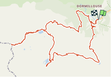

Length
23 km

Max alt
3090 m

Uphill gradient
1782 m
Km-Effort
47 km

Min alt
1436 m

Downhill gradient
1782 m
Boucle
Yes
Creation date :
2016-06-23 00:00:00.0
Updated on :
2016-06-23 00:00:00.0
9h00
Difficulty : Medium

FREE GPS app for hiking
 SityTrail
IGN / Geographical institutes
SityTrail Plus
The world is yours!
About
Trail Walking of 23 km to be discovered at Provence-Alpes-Côte d'Azur, Hautes-Alpes, Freissinières. This trail is proposed by dalla.anthony.
Photos


38 photos in total. Please click on a photo to see them all in the gallery.
Positioning
Country:
France
Region :
Provence-Alpes-Côte d'Azur
Department/Province :
Hautes-Alpes
Municipality :
Freissinières
Location:
Unknown
Start:(Dec)
Start:(UTM)
298049 ; 4956495 (32T) N.
Comments
très belle randonnée