


TRAIL FREE RUN DU 20/07/2019

jpb83
User
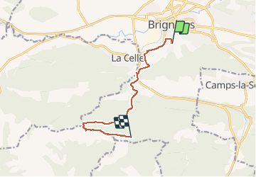

Length
9.4 km

Max alt
769 m

Uphill gradient
631 m
Km-Effort
16.6 km

Min alt
226 m

Downhill gradient
266 m
Boucle
No
Creation date :
2019-07-13 08:20:35.104
Updated on :
2019-07-13 08:22:11.719
3h33
Difficulty : Difficult
2h00
Difficulty : Medium

FREE GPS app for hiking
 SityTrail
IGN / Geographical institutes
SityTrail Plus
The world is yours!
About
Trail Walking of 9.4 km to be discovered at Provence-Alpes-Côte d'Azur, Var, Brignoles. This trail is proposed by jpb83.
Positioning
Country:
France
Region :
Provence-Alpes-Côte d'Azur
Department/Province :
Var
Municipality :
Brignoles
Location:
Unknown
Start:(Dec)
Start:(UTM)
262081 ; 4809378 (32T) N.
Comments