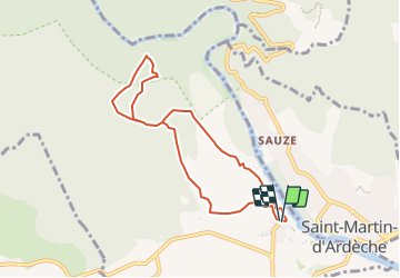
Trail Walking Aiguèze - Aiguèze - Photo
© OpenStreetMap contributors
Length
Length
7.7 km
Max alt
Max alt
279 m
Uphill gradient
Uphill gradient
245 m
Km-Effort
Km-Effort  
11 km
Min alt
Min alt
74 m
Downhill gradient
Downhill gradient
245 m
Boucle
Boucle
Yes
Creation date :
2014-12-10 00:00:00.0
Updated on :
2014-12-10 00:00:00.0

(1 Reviews)

Walking
Walking
2h30
Difficulty : Medium

Scan this QR Code to open this trail in the SityTrail application

FREE GPS app for hiking

Logo SityTrail SityTrail

IGN / Geographical institutes

Download SityTrail from the App Store Download SityTrail from Google Play

Logo SityTrail SityTrail Plus

The world is yours!

Download SityTrail from the App Store Download SityTrail from Google Play Download SityTrail on Huawei AppGallery

About

Trail Walking of 7.7 km to be discovered at Occitania, Gard, Aiguèze. This trail is proposed by rousseau.mich.

Description

Promenade au village d'Aiguèze, ravissant village de pierre niché au dessus de l'Ardèche, cette balade nous amènera au dessus des Gorges de l'Ardèche et à travers les vignes. D’autres informations et photos sur le site des Balades de Stéphane.

Elevation profile

Photos

Points of interest

Point of interest Aiguèze - Aiguèze - Photo
rousseau.mich
AIGUÈZE 

Positioning

Country:
France
Region :
Occitania
Department/Province :
Gard
Municipality :
Aiguèze
Location:
Unknown
Start:(UTM)
624112 ; 4906681 (31T) N.

Comments

Please log in to post a review or rate the element


Close
My subscriptions