


st martin d''ardeche

rousseau.mich
User
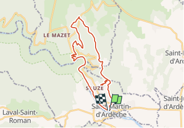

Length
16.3 km

Max alt
282 m

Uphill gradient
465 m
Km-Effort
23 km

Min alt
44 m

Downhill gradient
468 m
Boucle
Yes
Creation date :
2014-12-10 00:00:00.0
Updated on :
2014-12-10 00:00:00.0
--
Difficulty : Unknown

FREE GPS app for hiking
 SityTrail
IGN / Geographical institutes
SityTrail Plus
The world is yours!
About
Trail Other activity of 16.3 km to be discovered at Auvergne-Rhône-Alpes, Ardèche, Saint-Martin-d'Ardèche. This trail is proposed by rousseau.mich.
Description
ardeche entre mont et riviere
Positioning
Country:
France
Region :
Auvergne-Rhône-Alpes
Department/Province :
Ardèche
Municipality :
Saint-Martin-d'Ardèche
Location:
Unknown
Start:(Dec)
Start:(UTM)
624877 ; 4906508 (31T) N.
Comments