


la vigotte

breton111
User
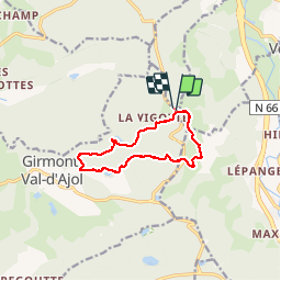

Length
9.4 km

Max alt
738 m

Uphill gradient
265 m
Km-Effort
12.9 km

Min alt
586 m

Downhill gradient
263 m
Boucle
Yes
Creation date :
2019-07-13 13:11:31.673
Updated on :
2019-07-13 15:43:14.819
2h31
Difficulty : Very easy

FREE GPS app for hiking
 SityTrail
IGN / Geographical institutes
SityTrail Plus
The world is yours!
About
Trail Walking of 9.4 km to be discovered at Grand Est, Vosges, Saint-Étienne-lès-Remiremont. This trail is proposed by breton111.
Description
superbe balade.
Positioning
Country:
France
Region :
Grand Est
Department/Province :
Vosges
Municipality :
Saint-Étienne-lès-Remiremont
Location:
Unknown
Start:(Dec)
Start:(UTM)
320956 ; 5315469 (32T) N.
Comments