


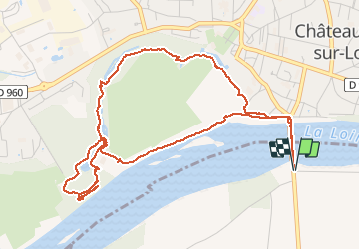
Chateauneuf sur Loire - le parc

ace003
User


1h33
Difficulty : Very easy

FREE GPS app for hiking
 SityTrail
IGN / Geographical institutes
SityTrail Plus
The world is yours!
About
Trail Walking of 6.2 km to be discovered at Centre-Loire Valley, Loiret, Sigloy. This trail is proposed by ace003.
Description
Une belle balade en boucle dans le parc de chateauneuf sur Loire.
Départ et arrivée : avant le pont dans l'allée du camping.
Guide réalisé le 17 aout 2013.
Photos


21 photos in total. Please click on a photo to see them all in the gallery.


Positioning
Comments