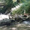
Gorges de Nan, Malleval

Steph0726
User

Length
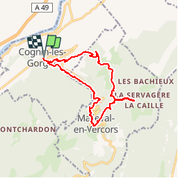
15.4 km

Max alt
1015 m

Uphill gradient
1130 m
Km-Effort
30 km

Min alt
275 m

Downhill gradient
1130 m
Boucle
Yes
Creation date :
2019-07-14 07:41:10.352
Updated on :
2019-07-22 06:46:44.271
6h07
Difficulty : Medium

FREE GPS app for hiking
 SityTrail
IGN / Geographical institutes
SityTrail Plus
The world is yours!
About
Trail Walking of 15.4 km to be discovered at Auvergne-Rhône-Alpes, Isère, Cognin-les-Gorges. This trail is proposed by Steph0726.
Photos


Positioning
Country:
France
Region :
Auvergne-Rhône-Alpes
Department/Province :
Isère
Municipality :
Cognin-les-Gorges
Location:
Unknown
Start:(Dec)
Start:(UTM)
689561 ; 5004746 (31T) N.
Comments