


col de Bramousse et fromage

Bernardb44
User
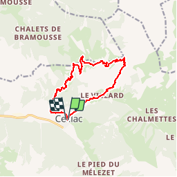

Length
14.8 km

Max alt
2559 m

Uphill gradient
944 m
Km-Effort
27 km

Min alt
1647 m

Downhill gradient
946 m
Boucle
Yes
Creation date :
2019-07-14 06:33:50.056
Updated on :
2019-07-14 15:20:22.725
7h19
Difficulty : Medium

FREE GPS app for hiking
 SityTrail
IGN / Geographical institutes
SityTrail Plus
The world is yours!
About
Trail Walking of 14.8 km to be discovered at Provence-Alpes-Côte d'Azur, Hautes-Alpes, Ceillac. This trail is proposed by Bernardb44.
Positioning
Country:
France
Region :
Provence-Alpes-Côte d'Azur
Department/Province :
Hautes-Alpes
Municipality :
Ceillac
Location:
Unknown
Start:(Dec)
Start:(UTM)
323870 ; 4948466 (32T) N.
Comments