


depart source de la loue

gerardmicheline
User
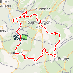

Length
21 km

Max alt
1041 m

Uphill gradient
834 m
Km-Effort
32 km

Min alt
544 m

Downhill gradient
836 m
Boucle
Yes
Creation date :
2019-07-15 07:18:34.911
Updated on :
2019-07-15 07:20:40.67
6h33
Difficulty : Very difficult

FREE GPS app for hiking
 SityTrail
IGN / Geographical institutes
SityTrail Plus
The world is yours!
About
Trail Walking of 21 km to be discovered at Bourgogne-Franche-Comté, Doubs, Ouhans. This trail is proposed by gerardmicheline.
Description
point culminant le mont Pelé
Positioning
Country:
France
Region :
Bourgogne-Franche-Comté
Department/Province :
Doubs
Municipality :
Ouhans
Location:
Unknown
Start:(Dec)
Start:(UTM)
294726 ; 5209485 (32T) N.
Comments