


Vissec

ARVIEU
User

Length
116 km

Max alt
743 m

Uphill gradient
2146 m
Km-Effort
145 km

Min alt
42 m

Downhill gradient
2137 m
Boucle
No
Creation date :
2019-07-15 13:41:20.769
Updated on :
2019-07-15 13:48:10.812
5h00
Difficulty : Difficult

FREE GPS app for hiking
 SityTrail
IGN / Geographical institutes
SityTrail Plus
The world is yours!
About
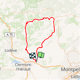
Trail Cycle of 116 km to be discovered at Occitania, Hérault, Gignac. This trail is proposed by ARVIEU.
Description
Gignac Vissec montdadier cazilhac St Guilhem gignac
Positioning
Country:
France
Region :
Occitania
Department/Province :
Hérault
Municipality :
Gignac
Location:
Unknown
Start:(Dec)
Start:(UTM)
544318 ; 4833835 (31T) N.
Comments