


Le Lioran - Prat de Bouc

togolo28
User
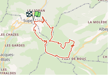

Length
18.8 km

Max alt
1839 m

Uphill gradient
1046 m
Km-Effort
33 km

Min alt
1236 m

Downhill gradient
1046 m
Boucle
Yes
Creation date :
2019-07-15 07:38:41.002
Updated on :
2019-07-15 14:38:33.791
5h45
Difficulty : Difficult

FREE GPS app for hiking
 SityTrail
IGN / Geographical institutes
SityTrail Plus
The world is yours!
About
Trail Walking of 18.8 km to be discovered at Auvergne-Rhône-Alpes, Cantal, Laveissière. This trail is proposed by togolo28.
Positioning
Country:
France
Region :
Auvergne-Rhône-Alpes
Department/Province :
Cantal
Municipality :
Laveissière
Location:
Unknown
Start:(Dec)
Start:(UTM)
480151 ; 4992164 (31T) N.
Comments