


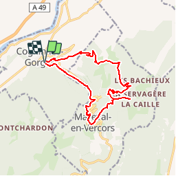
COGNIN LES GORGES DU NAN CASCADE GERLETTE

Nathy8913
User

Length
15.1 km

Max alt
1135 m

Uphill gradient
1245 m
Km-Effort
32 km

Min alt
286 m

Downhill gradient
1244 m
Boucle
Yes
Creation date :
2019-07-15 13:55:30.816
Updated on :
2019-07-15 13:59:19.066
6h15
Difficulty : Medium

FREE GPS app for hiking
 SityTrail
IGN / Geographical institutes
SityTrail Plus
The world is yours!
About
Trail Walking of 15.1 km to be discovered at Auvergne-Rhône-Alpes, Isère, Cognin-les-Gorges. This trail is proposed by Nathy8913.
Positioning
Country:
France
Region :
Auvergne-Rhône-Alpes
Department/Province :
Isère
Municipality :
Cognin-les-Gorges
Location:
Unknown
Start:(Dec)
Start:(UTM)
689703 ; 5004521 (31T) N.
Comments