


Longemer

jpblimond
User
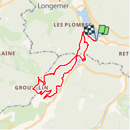

Length
16.1 km

Max alt
1129 m

Uphill gradient
606 m
Km-Effort
24 km

Min alt
739 m

Downhill gradient
600 m
Boucle
Yes
Creation date :
2019-07-15 11:25:45.56
Updated on :
2019-07-16 07:22:00.138
5h27
Difficulty : Medium

FREE GPS app for hiking
 SityTrail
IGN / Geographical institutes
SityTrail Plus
The world is yours!
About
Trail Walking of 16.1 km to be discovered at Grand Est, Vosges, Xonrupt-Longemer. This trail is proposed by jpblimond.
Positioning
Country:
France
Region :
Grand Est
Department/Province :
Vosges
Municipality :
Xonrupt-Longemer
Location:
Unknown
Start:(Dec)
Start:(UTM)
347736 ; 5325345 (32U) N.
Comments