


villardonnel

Mascart
User
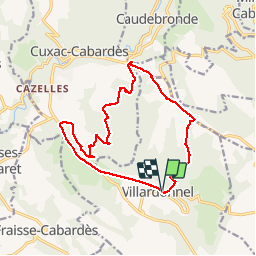

Length
16.5 km

Max alt
558 m

Uphill gradient
400 m
Km-Effort
22 km

Min alt
304 m

Downhill gradient
400 m
Boucle
Yes
Creation date :
2019-07-16 06:25:13.735
Updated on :
2019-07-16 14:28:56.529
4h12
Difficulty : Difficult

FREE GPS app for hiking
 SityTrail
IGN / Geographical institutes
SityTrail Plus
The world is yours!
About
Trail Walking of 16.5 km to be discovered at Occitania, Aude, Villardonnel. This trail is proposed by Mascart.
Description
Détour 6 kms
Positioning
Country:
France
Region :
Occitania
Department/Province :
Aude
Municipality :
Villardonnel
Location:
Unknown
Start:(Dec)
Start:(UTM)
444232 ; 4798276 (31T) N.
Comments