


Ile de Porquerolles

patbt
User
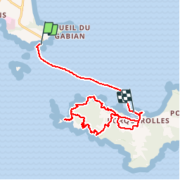

Length
18.8 km

Max alt
74 m

Uphill gradient
213 m
Km-Effort
22 km

Min alt
-1 m

Downhill gradient
213 m
Boucle
No
Creation date :
2016-03-09 00:00:00.0
Updated on :
2016-03-09 00:00:00.0
4h14
Difficulty : Medium

FREE GPS app for hiking
 SityTrail
IGN / Geographical institutes
SityTrail Plus
The world is yours!
About
Trail Walking of 18.8 km to be discovered at Provence-Alpes-Côte d'Azur, Var, Hyères. This trail is proposed by patbt.
Positioning
Country:
France
Region :
Provence-Alpes-Côte d'Azur
Department/Province :
Var
Municipality :
Hyères
Location:
Unknown
Start:(Dec)
Start:(UTM)
268162 ; 4767782 (32T) N.
Comments