


Sprimont Pays de Herve Sprimont

pqa621@gmail.com
User
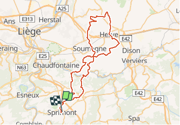

Length
66 km

Max alt
316 m

Uphill gradient
1076 m
Km-Effort
80 km

Min alt
93 m

Downhill gradient
1060 m
Boucle
No
Creation date :
2014-12-10 00:00:00.0
Updated on :
2014-12-10 00:00:00.0
3h07
Difficulty : Medium

FREE GPS app for hiking
 SityTrail
IGN / Geographical institutes
SityTrail Plus
The world is yours!
About
Trail Cycle of 66 km to be discovered at Wallonia, Liège, Sprimont. This trail is proposed by pqa621@gmail.com.
Description
Petites routes bucoliques par monts et par vaux délivrant de superbes paysages du plateau de Herve
Positioning
Country:
Belgium
Region :
Wallonia
Department/Province :
Liège
Municipality :
Sprimont
Location:
Sprimont
Start:(Dec)
Start:(UTM)
688619 ; 5598918 (31U) N.
Comments