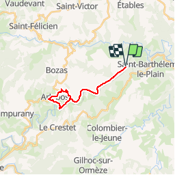
Trail Cycle Colombier-le-Vieux - colombier-arlebosc - Photo
 bob2023
bob2023

User

© OpenStreetMap contributors
Length
Length
19 km
Max alt
Max alt
429 m
Uphill gradient
Uphill gradient
325 m
Km-Effort
Km-Effort  
23 km
Min alt
Min alt
238 m
Downhill gradient
Downhill gradient
326 m
Boucle
Boucle
Yes
Creation date :
2018-08-26 08:32:34.928
Updated on :
2018-08-26 08:32:34.94

(0 Reviews)

Cycle
Cycle
1h21
Difficulty : Medium

Scan this QR Code to open this trail in the SityTrail application

FREE GPS app for hiking

Logo SityTrail SityTrail

IGN / Geographical institutes

Download SityTrail from the App Store Download SityTrail from Google Play

Logo SityTrail SityTrail Plus

The world is yours!

Download SityTrail from the App Store Download SityTrail from Google Play Download SityTrail on Huawei AppGallery

About

Trail Cycle of 19 km to be discovered at Auvergne-Rhône-Alpes, Ardèche, Colombier-le-Vieux. This trail is proposed by bob2023.

Description

Se garer au parking au bord du Doux après lieu dit Gray (air de pique nique).
Il y a une partie VTT après Boucieu au croisement lieu dit Bareyron, possibilité de poursuivre par la route jusqu'a le Chapiton.
Pour la descente après Arlebosc prévoir de bons freins. Note 7/10

Elevation profile

Positioning

Country:
France
Region :
Auvergne-Rhône-Alpes
Department/Province :
Ardèche
Municipality :
Colombier-le-Vieux
Location:
Unknown
Start:(UTM)
635568 ; 4990826 (31T) N.


Close
My subscriptions