Trail Walking Palasca - Punta d'Arco direct - Photo

Punta d'Arco direct

© OpenStreetMap contributors
Length
Length
5.8 km
Max alt
Max alt
310 m
Uphill gradient
Uphill gradient
276 m
Km-Effort
Km-Effort  
9.5 km
Min alt
Min alt
45 m
Downhill gradient
Downhill gradient
280 m
Boucle
Boucle
Yes
Creation date :
2014-12-10 00:00:00.0
Updated on :
2014-12-10 00:00:00.0

(0 Reviews)

Walking
Walking
2h01
Difficulty : Easy

Scan this QR Code to open this trail in the SityTrail application

FREE GPS app for hiking

Logo SityTrail SityTrail

IGN / Geographical institutes

Download SityTrail from the App Store Download SityTrail from Google Play

Logo SityTrail SityTrail Plus

The world is yours!

Download SityTrail from the App Store Download SityTrail from Google Play Download SityTrail on Huawei AppGallery

About

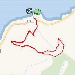
Trail Walking of 5.8 km to be discovered at Corsica, Haute-Corse, Palasca. This trail is proposed by jmheydorff.

Description

Parking, sur RN 197, 1,5 km à l'Est de Lozari: larg esplanade dans un virage.
remonter le vallon, juste en face du pkg, sur un sentier très broussailleux; après 1,3 km, on atteint un belvédère (alt.170m); pour avoir une vue encore   large, on va monter sur la pointe d'Arco (alt.320m), par la large piste, qui relie les 2 plages de Lozari et de l'Ostriconi

Elevation profile

Positioning

Country:
France
Region :
Corsica
Department/Province :
Haute-Corse
Municipality :
Palasca
Location:
Unknown
Start:(UTM)
502900 ; 4722336 (32T) N.


Close
My subscriptions