


dun galinié fait

pidjam
User
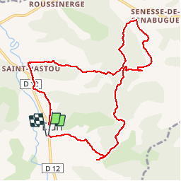

Length
11 km

Max alt
529 m

Uphill gradient
347 m
Km-Effort
15.6 km

Min alt
322 m

Downhill gradient
347 m
Boucle
Yes
Creation date :
2019-07-21 07:04:47.096
Updated on :
2019-07-21 10:12:38.476
3h07
Difficulty : Medium

FREE GPS app for hiking
 SityTrail
IGN / Geographical institutes
SityTrail Plus
The world is yours!
About
Trail Walking of 11 km to be discovered at Occitania, Ariège, Dun. This trail is proposed by pidjam.
Positioning
Country:
France
Region :
Occitania
Department/Province :
Ariège
Municipality :
Dun
Location:
Unknown
Start:(Dec)
Start:(UTM)
402224 ; 4764429 (31T) N.
Comments