


. mont Avril

clozelmarie
User
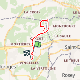

Length
4.5 km

Max alt
414 m

Uphill gradient
166 m
Km-Effort
6.7 km

Min alt
257 m

Downhill gradient
152 m
Boucle
No
Creation date :
2019-07-22 05:50:29.169
Updated on :
2019-07-22 07:36:16.618
1h30
Difficulty : Very easy

FREE GPS app for hiking
 SityTrail
IGN / Geographical institutes
SityTrail Plus
The world is yours!
About
Trail Walking of 4.5 km to be discovered at Bourgogne-Franche-Comté, Saône-et-Loire, Moroges. This trail is proposed by clozelmarie.
Positioning
Country:
France
Region :
Bourgogne-Franche-Comté
Department/Province :
Saône-et-Loire
Municipality :
Moroges
Location:
Unknown
Start:(Dec)
Start:(UTM)
628790 ; 5179033 (31T) N.
Comments