


SityTrail - 2065875 - tete-de-rissace---le-longet

Massiac15
User

Length
14.4 km

Max alt
2940 m

Uphill gradient
1289 m
Km-Effort
31 km

Min alt
1882 m

Downhill gradient
1115 m
Boucle
No
Creation date :
2019-07-23 07:18:34.102
Updated on :
2019-07-24 16:11:05.506
6h12
Difficulty : Very difficult

FREE GPS app for hiking
 SityTrail
IGN / Geographical institutes
SityTrail Plus
The world is yours!
About
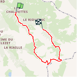
Trail Walking of 14.4 km to be discovered at Provence-Alpes-Côte d'Azur, Hautes-Alpes, Ceillac. This trail is proposed by Massiac15.
Description
Montée par le vallon de Beaubarnon et retour par le col de Clausis et le lac. ( Navette )
Point de vue magnifique à la tête de Rissace
Positioning
Country:
France
Region :
Provence-Alpes-Côte d'Azur
Department/Province :
Hautes-Alpes
Municipality :
Ceillac
Location:
Unknown
Start:(Dec)
Start:(UTM)
327101 ; 4948343 (32T) N.
Comments