


parcours 35km

mthomas30
User
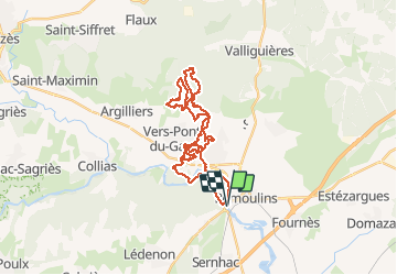

Length
35 km

Max alt
172 m

Uphill gradient
503 m
Km-Effort
42 km

Min alt
14 m

Downhill gradient
504 m
Boucle
Yes
Creation date :
2019-07-23 09:51:31.948
Updated on :
2019-07-23 10:03:57.112
3h40
Difficulty : Medium

FREE GPS app for hiking
 SityTrail
IGN / Geographical institutes
SityTrail Plus
The world is yours!
About
Trail Mountain bike of 35 km to be discovered at Occitania, Gard, Remoulins. This trail is proposed by mthomas30.
Positioning
Country:
France
Region :
Occitania
Department/Province :
Gard
Municipality :
Remoulins
Location:
Unknown
Start:(Dec)
Start:(UTM)
625143 ; 4866022 (31T) N.
Comments