


lac de bastampe

chasle
User
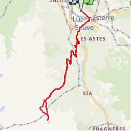

Length
21 km

Max alt
2082 m

Uphill gradient
1503 m
Km-Effort
41 km

Min alt
677 m

Downhill gradient
1503 m
Boucle
Yes
Creation date :
2019-07-23 04:49:52.114
Updated on :
2019-07-23 15:09:15.397
8h19
Difficulty : Very easy

FREE GPS app for hiking
 SityTrail
IGN / Geographical institutes
SityTrail Plus
The world is yours!
About
Trail Walking of 21 km to be discovered at Occitania, Hautespyrenees, Esquièze-Sère. This trail is proposed by chasle.
Positioning
Country:
France
Region :
Occitania
Department/Province :
Hautespyrenees
Municipality :
Esquièze-Sère
Location:
Unknown
Start:(Dec)
Start:(UTM)
744314 ; 4751619 (30T) N.
Comments