


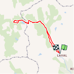
Lacs de ma claree

antoine.demaison
User

Length
16.3 km

Max alt
2491 m

Uphill gradient
542 m
Km-Effort
24 km

Min alt
2021 m

Downhill gradient
542 m
Boucle
Yes
Creation date :
2019-07-23 06:49:49.012
Updated on :
2019-07-23 16:21:21.946
8h34
Difficulty : Medium

FREE GPS app for hiking
 SityTrail
IGN / Geographical institutes
SityTrail Plus
The world is yours!
About
Trail Walking of 16.3 km to be discovered at Provence-Alpes-Côte d'Azur, Hautes-Alpes, Névache. This trail is proposed by antoine.demaison.
Description
Depuis refuge de Laval.
Positioning
Country:
France
Region :
Provence-Alpes-Côte d'Azur
Department/Province :
Hautes-Alpes
Municipality :
Névache
Location:
Unknown
Start:(Dec)
Start:(UTM)
305230 ; 4992482 (32T) N.
Comments