


Téton Venus

crognon
User

Length
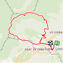
10.4 km
Boucle
Yes
Creation date :
2019-07-24 06:47:49.267
Updated on :
2019-07-24 13:40:17.66
6h51
Difficulty : Difficult

FREE GPS app for hiking
 SityTrail
IGN / Geographical institutes
SityTrail Plus
The world is yours!
About
Trail Walking of 10.4 km to be discovered at Auvergne-Rhône-Alpes, Cantal, Laveissière. This trail is proposed by crognon.
Positioning
Country:
France
Region :
Auvergne-Rhône-Alpes
Department/Province :
Cantal
Municipality :
Laveissière
Location:
Unknown
Start:(Dec)
Start:(UTM)
480161 ; 4992228 (31T) N.
Comments