


55 Montagne claret

guy07
User
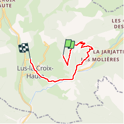

Length
10 km

Max alt
1720 m

Uphill gradient
499 m
Km-Effort
17.5 km

Min alt
1000 m

Downhill gradient
747 m
Boucle
No
Creation date :
2019-07-05 07:06:56.678
Updated on :
2019-07-25 08:02:15.901
3h41
Difficulty : Very easy

FREE GPS app for hiking
 SityTrail
IGN / Geographical institutes
SityTrail Plus
The world is yours!
About
Trail Walking of 10 km to be discovered at Auvergne-Rhône-Alpes, Drôme, Lus-la-Croix-Haute. This trail is proposed by guy07.
Positioning
Country:
France
Region :
Auvergne-Rhône-Alpes
Department/Province :
Drôme
Municipality :
Lus-la-Croix-Haute
Location:
Unknown
Start:(Dec)
Start:(UTM)
715995 ; 4950359 (31T) N.
Comments