


les trois perles de la gervane

Joel26400
User
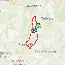

Length
20 km

Max alt
1015 m

Uphill gradient
839 m
Km-Effort
31 km

Min alt
394 m

Downhill gradient
836 m
Boucle
No
Creation date :
2019-07-25 05:59:01.254
Updated on :
2019-07-25 15:30:39.931
8h17
Difficulty : Very easy

FREE GPS app for hiking
 SityTrail
IGN / Geographical institutes
SityTrail Plus
The world is yours!
About
Trail Walking of 20 km to be discovered at Auvergne-Rhône-Alpes, Drôme, Plan-de-Baix. This trail is proposed by Joel26400.
Description
cite super rando raprechissante
Positioning
Country:
France
Region :
Auvergne-Rhône-Alpes
Department/Province :
Drôme
Municipality :
Plan-de-Baix
Location:
Unknown
Start:(Dec)
Start:(UTM)
672927 ; 4967301 (31T) N.
Comments