


litoues

chasle
User
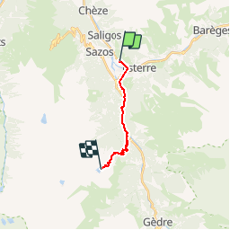

Length
12.1 km

Max alt
2092 m

Uphill gradient
1521 m
Km-Effort
28 km

Min alt
684 m

Downhill gradient
115 m
Boucle
No
Creation date :
2019-07-24 18:24:16.377
Updated on :
2019-07-25 19:05:57.363
4h24
Difficulty : Very difficult

FREE GPS app for hiking
 SityTrail
IGN / Geographical institutes
SityTrail Plus
The world is yours!
About
Trail Walking of 12.1 km to be discovered at Occitania, Hautespyrenees, Esquièze-Sère. This trail is proposed by chasle.
Positioning
Country:
France
Region :
Occitania
Department/Province :
Hautespyrenees
Municipality :
Esquièze-Sère
Location:
Unknown
Start:(Dec)
Start:(UTM)
744254 ; 4751677 (30T) N.
Comments