


Sazos/Grust/Viscos

chasle
User
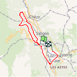

Length
9.4 km

Max alt
1182 m

Uphill gradient
443 m
Km-Effort
15.3 km

Min alt
804 m

Downhill gradient
449 m
Boucle
Yes
Creation date :
2019-07-26 12:00:07.994
Updated on :
2024-10-01 20:55:51.777
3h28
Difficulty : Difficult

FREE GPS app for hiking
 SityTrail
IGN / Geographical institutes
SityTrail Plus
The world is yours!
About
Trail Walking of 9.4 km to be discovered at Occitania, Hautespyrenees, Sazos. This trail is proposed by chasle.
Positioning
Country:
France
Region :
Occitania
Department/Province :
Hautespyrenees
Municipality :
Sazos
Location:
Unknown
Start:(Dec)
Start:(UTM)
743017 ; 4752149 (30T) N.
Comments