


Traversée de la Baie du 28/07/2019

VANDERPUTTENMi
User GUIDE
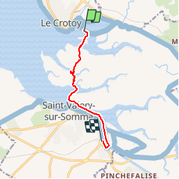

Length
6.4 km

Max alt
6 m

Uphill gradient
18 m
Km-Effort
6.6 km

Min alt
0 m

Downhill gradient
14 m
Boucle
No
Creation date :
2019-07-27 12:22:52.868
Updated on :
2019-07-31 02:53:04.508
2h26
Difficulty : Very easy

FREE GPS app for hiking
 SityTrail
IGN / Geographical institutes
SityTrail Plus
The world is yours!
About
Trail Walking of 6.4 km to be discovered at Hauts-de-France, Somme, Favières. This trail is proposed by VANDERPUTTENMi.
Positioning
Country:
France
Region :
Hauts-de-France
Department/Province :
Somme
Municipality :
Favières
Location:
Unknown
Start:(Dec)
Start:(UTM)
402668 ; 5563289 (31U) N.
Comments