


Etape 1 GTJ : Mandeure à Pont de Roide

annefrance70
User
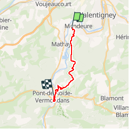

Length
14 km

Max alt
589 m

Uphill gradient
311 m
Km-Effort
18.1 km

Min alt
334 m

Downhill gradient
296 m
Boucle
No
Creation date :
2019-07-28 08:28:40.058
Updated on :
2019-08-04 19:48:18.657
4h40
Difficulty : Easy

FREE GPS app for hiking
 SityTrail
IGN / Geographical institutes
SityTrail Plus
The world is yours!
About
Trail Walking of 14 km to be discovered at Bourgogne-Franche-Comté, Doubs, Mandeure. This trail is proposed by annefrance70.
Photos


Positioning
Country:
France
Region :
Bourgogne-Franche-Comté
Department/Province :
Doubs
Municipality :
Mandeure
Location:
Unknown
Start:(Dec)
Start:(UTM)
333847 ; 5257477 (32T) N.
Comments