Trail Walking Chuyer - 19eme rando des Mil''pattes - Chuyer - Photo

19eme rando des Mil''pattes - Chuyer

 tracegps
tracegps

User

© OpenStreetMap contributors
Length
Length
18 km
Max alt
Max alt
759 m
Uphill gradient
Uphill gradient
679 m
Km-Effort
Km-Effort  
27 km
Min alt
Min alt
440 m
Downhill gradient
Downhill gradient
672 m
Boucle
Boucle
Yes
Creation date :
2014-12-10 00:00:00.0
Updated on :
2014-12-10 00:00:00.0

(0 Reviews)

Walking
Walking
5h00
Difficulty : Medium

Scan this QR Code to open this trail in the SityTrail application

FREE GPS app for hiking

Logo SityTrail SityTrail

IGN / Geographical institutes

Download SityTrail from the App Store Download SityTrail from Google Play

Logo SityTrail SityTrail World

The world is yours!

Download SityTrail from the App Store Download SityTrail from Google Play Download SityTrail on Huawei AppGallery

About

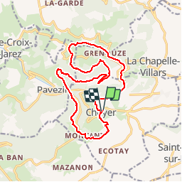
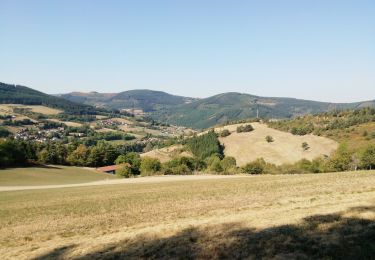
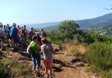
Trail Walking of 18 km to be discovered at Auvergne-Rhône-Alpes, Loire, Chuyer. This trail is proposed by tracegps.

Description

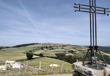
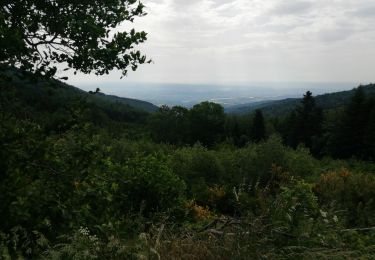
Le 07 avril 2013, 19eme Rando organisée par le club du village de Chuyer, les Mil'pattes. 754M /-, passage au col de Grenouze et col de Pavézin. Jolie vue sur la Vallée du Rhône.

Elevation profile

Photos

Positioning

Country:
France
Region :
Auvergne-Rhône-Alpes
Department/Province :
Loire
Municipality :
Chuyer
Location:
Unknown
Start:(UTM)
632515 ; 5035237 (31T) N.

Trails nearby

Trail Walking Chuyer - Autour du mont Ministre - Photo
Walking
pcostet

Walking

Easy
(2)
Chuyer, Auvergne-Rhône-Alpes, Loire, France
7.5 km | 11.2 km-effort
Unknown
Yes
Trail Walking Pélussin - Randonnée du tacot à Pelussin  - Photo
Walking
dudu42

Walking

Difficult
Pélussin, Auvergne-Rhône-Alpes, Loire, France
17.5 km | 26 km-effort
3h 55min
No
Trail Walking Chuyer - 42-Chuyer-mont-Ministre-19km-685m-été - Photo
Walking
SyMA

Walking

Medium
Chuyer, Auvergne-Rhône-Alpes, Loire, France
19 km | 28 km-effort
5h 50min
Yes
Trail Walking Sainte-Croix-en-Jarez - 42-ste-Croix-Jarez-12km-440m-mai22 - Photo
Walking
SyMA

Walking

Medium
Sainte-Croix-en-Jarez, Auvergne-Rhône-Alpes, Loire, France
12 km | 17.9 km-effort
3h 5min
Yes
Trail On foot La Chapelle-Villars - Pilat N°30: des «Côteaux à les Haies» - Photo
On foot
PRO

On foot

Difficult
La Chapelle-Villars, Auvergne-Rhône-Alpes, Loire, France
29 km | 37 km-effort
8h 27min
Yes
Trail Walking Pélussin - 42 pelussin - Photo
Walking
himba26100

Walking

Easy
Pélussin, Auvergne-Rhône-Alpes, Loire, France
14.5 km | 22 km-effort
5h 13min
No
Trail Walking Pélussin - 42-Croix-Montvieux-20km-630m-juin21 - Photo
Walking
SyMA

Walking

Medium
Pélussin, Auvergne-Rhône-Alpes, Loire, France
20 km | 28 km-effort
5h 29min
Yes
Trail Walking Doizieux - 42  croix Montvieux collet de Doizieux 19km 650m - Photo
Walking
SyMA

Walking

Easy
Doizieux, Auvergne-Rhône-Alpes, Loire, France
19 km | 28 km-effort
5h 42min
Yes
Trail Walking Pavezin - Crêt de Baronnette - Photo
Walking
gerard1222

Walking

Easy
Pavezin, Auvergne-Rhône-Alpes, Loire, France
9.1 km | 13.6 km-effort
3h 20min
Yes


Close
My subscriptions