


merelle

Steinier
User
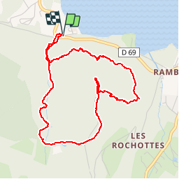

Length
5 km

Max alt
891 m

Uphill gradient
270 m
Km-Effort
8.6 km

Min alt
673 m

Downhill gradient
279 m
Boucle
Yes
Creation date :
2019-07-28 14:21:24.904
Updated on :
2019-07-29 09:28:34.927
1h55
Difficulty : Medium

FREE GPS app for hiking
 SityTrail
IGN / Geographical institutes
SityTrail Plus
The world is yours!
About
Trail Walking of 5 km to be discovered at Grand Est, Vosges, Gérardmer. This trail is proposed by Steinier.
Description
cascade
Positioning
Country:
France
Region :
Grand Est
Department/Province :
Vosges
Municipality :
Gérardmer
Location:
Unknown
Start:(Dec)
Start:(UTM)
339082 ; 5326048 (32U) N.
Comments