


L'Echalp - Col d'Agnel

soca
User
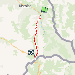

Length
10 km

Max alt
2806 m

Uphill gradient
1134 m
Km-Effort
22 km

Min alt
1696 m

Downhill gradient
104 m
Boucle
No
Creation date :
2019-07-30 14:06:20.063
Updated on :
2019-07-30 14:11:40.069
4h51
Difficulty : Very difficult

FREE GPS app for hiking
 SityTrail
IGN / Geographical institutes
SityTrail Plus
The world is yours!
About
Trail Walking of 10 km to be discovered at Provence-Alpes-Côte d'Azur, Hautes-Alpes, Abriès-Ristolas. This trail is proposed by soca.
Positioning
Country:
France
Region :
Provence-Alpes-Côte d'Azur
Department/Province :
Hautes-Alpes
Municipality :
Abriès-Ristolas
Location:
Ristolas
Start:(Dec)
Start:(UTM)
341079 ; 4957884 (32T) N.
Comments