


Mirepoix La Voie verte

Maca8284
User
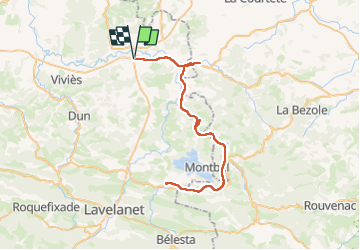

Length
67 km

Max alt
436 m

Uphill gradient
676 m
Km-Effort
76 km

Min alt
303 m

Downhill gradient
676 m
Boucle
Yes
Creation date :
2014-12-10 00:00:00.0
Updated on :
2014-12-10 00:00:00.0
5h07
Difficulty : Medium

FREE GPS app for hiking
 SityTrail
IGN / Geographical institutes
SityTrail Plus
The world is yours!
About
Trail Cycle of 67 km to be discovered at Occitania, Ariège, Mirepoix. This trail is proposed by Maca8284.
Description
A faire
Positioning
Country:
France
Region :
Occitania
Department/Province :
Ariège
Municipality :
Mirepoix
Location:
Unknown
Start:(Dec)
Start:(UTM)
408603 ; 4770794 (31T) N.
Comments