


Frasniere

vindju
User
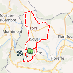

Length
15 km

Max alt
184 m

Uphill gradient
233 m
Km-Effort
18.1 km

Min alt
80 m

Downhill gradient
226 m
Boucle
No
Creation date :
2019-08-01 11:24:48.0
Updated on :
2019-08-25 13:20:19.109
4h41
Difficulty : Unknown

FREE GPS app for hiking
 SityTrail
IGN / Geographical institutes
SityTrail Plus
The world is yours!
About
Trail Walking of 15 km to be discovered at Wallonia, Namur, Floreffe. This trail is proposed by vindju.

Positioning
Country:
Belgium
Region :
Wallonia
Department/Province :
Namur
Municipality :
Floreffe
Location:
Franière
Start:(Dec)
Start:(UTM)
622235 ; 5588458 (31U) N.
Comments