


but saint genix

Joel26400
User

Length
19 km

Max alt
1619 m

Uphill gradient
1051 m
Km-Effort
33 km

Min alt
606 m

Downhill gradient
1051 m
Boucle
Yes
Creation date :
2019-08-01 05:47:31.15
Updated on :
2019-08-02 06:15:43.892
7h30
Difficulty : Very easy

FREE GPS app for hiking
 SityTrail
IGN / Geographical institutes
SityTrail Plus
The world is yours!
About
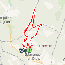
Trail Walking of 19 km to be discovered at Auvergne-Rhône-Alpes, Drôme, Marignac-en-Diois. This trail is proposed by Joel26400.
Description
rando
Positioning
Country:
France
Region :
Auvergne-Rhône-Alpes
Department/Province :
Drôme
Municipality :
Marignac-en-Diois
Location:
Unknown
Start:(Dec)
Start:(UTM)
683683 ; 4963617 (31T) N.
Comments