


croisement 4 chemins au- dessus des montagnès

Dupleix
User
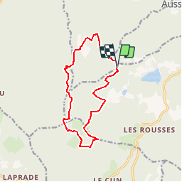

Length
13.8 km

Max alt
908 m

Uphill gradient
341 m
Km-Effort
18.3 km

Min alt
727 m

Downhill gradient
340 m
Boucle
Yes
Creation date :
2019-08-02 13:17:35.35
Updated on :
2019-08-02 13:22:45.433
3h54
Difficulty : Difficult

FREE GPS app for hiking
 SityTrail
IGN / Geographical institutes
SityTrail Plus
The world is yours!
About
Trail Walking of 13.8 km to be discovered at Occitania, Tarn, Mazamet. This trail is proposed by Dupleix.
Description
boucle,passant a la metairie neuve,prat-nouvel, sagne grande,le sebat haut,cos de laurens, la calmille,baucoup de sous bois
Positioning
Country:
France
Region :
Occitania
Department/Province :
Tarn
Municipality :
Mazamet
Location:
Unknown
Start:(Dec)
Start:(UTM)
445384 ; 4812739 (31T) N.
Comments