


Mont Chauve 020819

newman
User
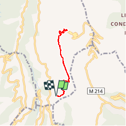

Length
6.2 km

Max alt
822 m

Uphill gradient
385 m
Km-Effort
11.4 km

Min alt
427 m

Downhill gradient
385 m
Boucle
Yes
Creation date :
2019-08-02 15:57:23.833
Updated on :
2019-08-02 21:27:57.852
1h08
Difficulty : Very easy

FREE GPS app for hiking
 SityTrail
IGN / Geographical institutes
SityTrail Plus
The world is yours!
About
Trail Walking of 6.2 km to be discovered at Provence-Alpes-Côte d'Azur, Maritime Alps, Aspremont. This trail is proposed by newman.
Positioning
Country:
France
Region :
Provence-Alpes-Côte d'Azur
Department/Province :
Maritime Alps
Municipality :
Aspremont
Location:
Unknown
Start:(Dec)
Start:(UTM)
359085 ; 4846024 (32T) N.
Comments