Trail Via ferrata Frauenfeld - Frauenfeld bis zur Thurmündung (Rhein) - Photo

Frauenfeld bis zur Thurmündung (Rhein)

 redfam01
redfam01

User

© OpenStreetMap contributors
Length
Length
61 km
Max alt
Max alt
420 m
Uphill gradient
Uphill gradient
594 m
Km-Effort
Km-Effort  
68 km
Min alt
Min alt
345 m
Downhill gradient
Downhill gradient
594 m
Boucle
Boucle
Yes
Creation date :
2014-12-11 00:00:00.0
Updated on :
2014-12-11 00:00:00.0

(0 Reviews)

Via ferrata
Via ferrata
--
Difficulty : Unknown

Scan this QR Code to open this trail in the SityTrail application

FREE GPS app for hiking

Logo SityTrail SityTrail

IGN / Geographical institutes

Download SityTrail from the App Store Download SityTrail from Google Play

Logo SityTrail SityTrail World

The world is yours!

Download SityTrail from the App Store Download SityTrail from Google Play Download SityTrail on Huawei AppGallery

About

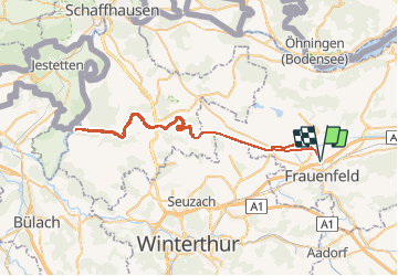
Trail Via ferrata of 61 km to be discovered at Thurgau, Bezirk Frauenfeld, Frauenfeld. This trail is proposed by redfam01.

Description

Rundtour Chur - Lenzerheide - Rothorn - Chur

Elevation profile

Positioning

Country:
Switzerland
Region :
Thurgau
Department/Province :
Bezirk Frauenfeld
Municipality :
Frauenfeld
Location:
Unknown
Start:(UTM)
492154 ; 5268332 (32T) N.

Trails nearby

Trail On foot Frauenfeld - Planetenweg Frauenfeld - Photo
On foot
PRO

On foot

Easy
Frauenfeld, Thurgau, Bezirk Frauenfeld, Switzerland
3.2 km | 4.1 km-effort
55min
No
Trail On foot Frauenfeld - Matzingen - Frauenfeld - Photo
On foot
PRO

On foot

Easy
Frauenfeld, Thurgau, Bezirk Frauenfeld, Switzerland
6.3 km | 8.2 km-effort
1h 51min
No
Trail Walking Frauenfeld - Frauenfeld - Tobel - Klosterweg 4 - Photo
Walking
hallauer

Walking

Very easy
Frauenfeld, Thurgau, Bezirk Frauenfeld, Switzerland
16.6 km | 23 km-effort
4h 30min
No


Close
My subscriptions